Youghiogheny River History
The Youghiogheny River is an incredible and unique resource, both as a natural and a cultural asset. It is a relatively “big water” river that flows from the crest of the Appalachians northward, flows 365 days a year and is an amazing cool temperature throughout the heat of the summer. Other rivers in the Mid-Atlantic may contain some of these qualities, but no other river has all of the them rolled into one package like the Yough.
The Yough River Basin has played an instrumental role in the development of our country, witnessing George Washington’s first battle, the development of the commerical coking industry, the first civil insurrection of the US, and launching the boats used by Lewis & Clark.
More recently, the superb water quality, consistent water volume, gradient, and water temperature have conspired to set the stage for the Youghiogheny River to be a national outdoor recreation destination.
GEOGRAPHY OF THE YOUGHIOGHENY RIVER VALLEY
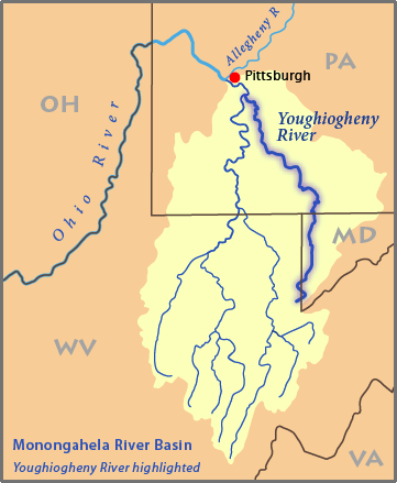 The Youghiogheny River (Yok-i-gay-nee), or the Yough (Yok) for short, is a 132-mile (216 km) tributary of the Monongahela River. Youghiogheny is a Native American word meaning “a stream flowing in a contrary direction”, or “a stream flowing in a roundabout course.” The uniqeness of the Yough starts, at the beginning.. it runs north throughout its entire course.
The source of the Youghiogheny is two springs on Backbone Mountain along the border of Maryland and West Virginia, southeast of the town of Aurora, WV. The ridge line above the springs is Hoyes Crest (3360′), the highest point in Maryland and the Eastern Continental Divide, with the headwaters of the North Branch of the Potomac on the other side, sending its water to the Atlantic. Below the springs the Yough meanders back and forth across the border, flowing into West Virginia and then it passes through Silver Lake before flowing northeast into Garrett County, Maryland. It then flows past Oakland, Maryland and roughly parallel to the West Virginia border. The river enters southwestern Pennsylvania on the border between Fayette and Somerset counties.
Amazingly 112 miles of the 132 miles of the Yough are navigable in one kind of a boat or another, beginning at the bridge in Oakland, Maryland the entire way to the mouth at the Monongahela River. The rapids on the river range from Class I to Class V rapids, so there’s something for boaters of all experience levels. The first paddlable section is called the “Top Yough” and is quite rowdy starting with 25′ Swallow Falls in Maryland, this is a class IV-V section of whitewater. Next up is the Upper Yough, beginning at Sang Run MD and extending to Friendsville, MD , this section is commercially rafted, thanks to dam releases from Deep Creek Lake. This section ends as it flows into the upper reaches of Yough Lake.
Upstream from Confluence, Pennsylvania, about six miles (9.7 km) north of Pennsylvania border, the river is impounded by the 184-foot-high (56 m) Youghiogheny Dam to form the Youghiogheny River Lake, a reservoir that stretches upstream into western Maryland. The dam was completed in 1943 primarily for flood control. Now the lake is one of Fayette County’s main recreation areas.
Below Yough Lake and between Confluence and Ohiopyle is the section of river known as the “Middle Yough“. This is an 11 mile section of class I-II whitewater that is surounded by Ohiopyle State Park, and an amazingly lovely canyon that feel like wilderness. This is an ideal piece of water for families with kids or those looking for a relaxing day on the water.
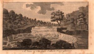
One of the key features of the Yough River is Ohiopyle Falls, a 19-foot waterfall located 100 yards away from Route 381. Below Ohiopyle Falls, the river bends around in a horseshoe curve, creating a “loop” in the river. The inside of the “loop” is Ferncliff Peninsula, a biologically important and diverse location that is a rare “National Natural Historical Landmark.” Boaters can start paddling at the put-in, run 1.5 miles of Class III rapids, get off the river at the end of the loop, and walk back to the start. A short, sweet paddling trip with no shuttle required! This is the beginning of the Lower Yough a 7 mile, class III gorge.
Over a quarter-million people visit Ohiopyle State Park each year. Whether they’re hiking, biking, or white-water rafting, nearly all of them take a minute to visit the striking Ohiopyle Falls. Although many people stop and take a photo here, few know its history and how this waterfall played an important role in the French and Indian War.
Sixteen miles downstream of Ohiopyle the Yough flows through Chestnut Gap in Chestnut Ridge, the western most uplift of the Appalachians, and past the town of Connellsville. The river has left the rough and tumble descent from the mountains and essentially enters the mid-west. The Youghiogheny’s journey draws to a close with its confluence with the Monongahela River at McKeesport, southeast of Pittsburgh. At this point the Youghiogheny has dropped 2000 feet from the source over 132 miles, from here it is 1900 miles to the Gulf of Mexico, and only 750 feet in elevation remaining to drop.
NATIVE AMERICAN & COLONIAL HISTORY OF THE YOUGHIOGHENY BASIN
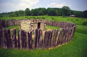
The first signs of inahabitants of the Youghiogheny basin date back approximatley 10,000 years. The Monongahela people lived here dating back about 1000 years, but vanshed from the landscape just prior to the arrival of european settlers in the early 1600’s. The Monongahela were mound builders and a prime example of their earth shaping can be seen at Fort Hill, 5 miles north east of Confluence. Following the Monongahela People, the Shawnee, Seneca and Delaware tribes utilized the area as a hunting grounds but not as a permanent home. In fact, the name Ohiopyle comes from the Lenape Indians, members of the Delaware nation. Their name for the area was “ahi opihəle” which means “it turns very white,” or “white frothy water” referring to the falls and the whitewater in the area.
In 1754, a young British colonel by the name of George Washington was scouting western Pennsylvania, trying to find a water route to quickly retake a fort at the Forks of the Ohio (present day Pittsburgh).
Washington floated the Yough from near the modern day location of Confluence towards Ohiopyle. As he grew closer to Ohiopyle the river quickens as he noted in his journal “The river became so rapid as to oblige us to come ashore..” This was in reference to what we now call Ohiopyle Falls, a 19 foot river wide falls.
Washington and his troops returned to the the main road (present day Route 40) to continue west by land.
His troops encountered and routed a small party of French soldiers in the Battle of Jumonville Glen. One of these soldiers escaped to Fort Duquesne. Washington was forced to quickly build a fort to prepare for the oncoming French attack, aptly named Fort Necessity, just to the southwest of Ohiopyle State Park. Washington’s forces were overwhelmed by the French and their Indian allies in the Battle of the Great Meadows at Fort Necessity. This was Washington’s only military surrender.
In 1794, farmers and whiskey distillers of the mid-Yough Valley took up arms against federal tax collectors. They were angered by the whiskey excise tax that had been enacted to help pay the war debt of the American Revolution. President Washington dispatched 12,000 troops to western Pennsylvania to confront what had now become known as the Whiskey Rebellion. This was the first critical test of the federal government’s authority and is credited as the catalyst for the founding of the Republican Party.
The history of floating on the Youghiogheny is a long one and even includes the original keelboat used by Lewis & Clark. Meriwether Lewis commissioned a 55-foot long, 8-foot wide keelboat that was constructed on the banks of the Youghiogheny in McKeesport in the summer of 1803. Infamously, the boat was completed 6 weeks late, costing the Corps of Discovery crucial time on their journey to explore the west.
FORESTRY, RAILROADS & TOURISM OF THE YOUGHIOGHENY VALLEY
The earliest settlers to the Youghiogheny Valley were farmers, trappers and hunters. The population of the area expanded after the National Road was built in 1811-1817 (present day US Route 40). This road passed near Ohiopyle and made it accessible, opening trade with eastern markets. Lumber became the dominant industry. Cooperages, tanneries, salt mining and coal mining were some of the smaller industries in the area.
The first rail line through the Yough Valley was the Pittsburgh and Connellsville Railroad Company that completed the line from Connellsville to the Maryland state line in 1871. This connection to the Baltimore and Ohio Railroad and the Western Maryland Railroad sped up the progress of the lumbering operations in the Yough Valley. Both railroads ultimatley built passenger stations in Ohiopyle, causing it to become the epicentre of commerce in the middle of the Yough Valley. Several narrow gauge railroads were built up into the surrounding mountains. These smaller railways were able to efficiently transport lumber to the sawmills and rail stations of Ohiopyle.
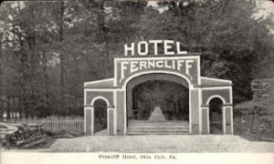
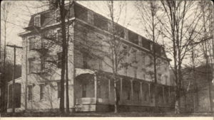
The railroads also brought tourists to Ohiopyle. It was affordable and close enough to Pittsburgh for a day trip. The round trip ride from Pittsburgh to Ohiopyle was just one dollar. Tourists flocked to the area to see the waterfalls and stay at the resorts that quickly sprouted up along the Youghiogheny River. In the early 1900’s there were 4 “Grand Hotels” located in the Ohiopyle area. These resorts had boardwalks, dancing pavilions, bowling alleys, fountains, tennis courts, and hiking trails, Ohiopyle became known as poor man’s Niagara.
But when the automobile rose to prominence, rail travel fell by the wayside. The resorts shut their doors forever. The buildings were torn down, and the forests regrew.
The Western Pennsylvania Conservancy purchased the land and then sold it to the Commonwealth of Pennsylvania. It was the first and largest park acquired under the Project 70 Land Acquisition and Borrowing Act. The governor approved the acquisition on August 8, 1964. Ohiopyle State Park was opened to the public in 1965 and formally dedicated in 1971.
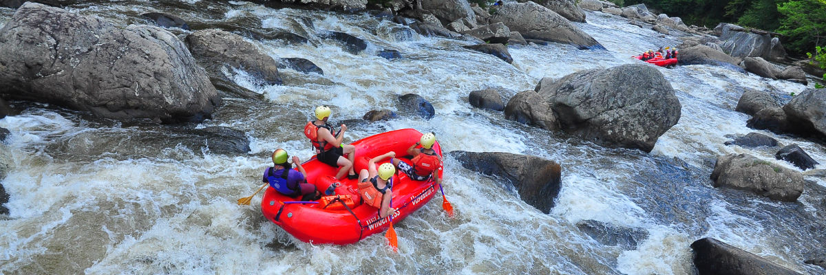
WHITEWATER RAFTING
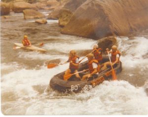
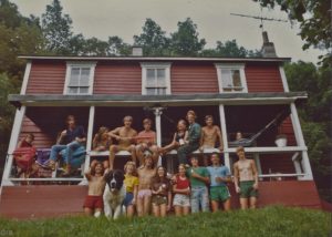
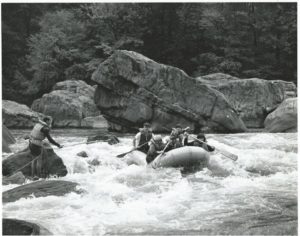
In 1963, Ohiopyle and the Youghiogheny became synonymous with whitewater rafting. Wilderness Voyageurs, under the ownership of Lance Martin, began commercial whitewater rafting on the Youghiogheny River. A then 21-year-old Lance Martin, his wife Lee and their friend Karl Kruger guided the first passengers down the Youghiogheny River that same year. This marked the start of the commercial rafting on the river, and the first commercial rafting trips east of the Mississippi!
In 1964, Karl and Lance inflated two surplus rafts and guided a few hundred passengers down the river. Their simple brochure invited visitors to “Go Raft the Yough,” and Wilderness Voyageurs was born. The founding of Ohiopyle State Park in the 1960s put the Yough permanently on the adventure map. Only an hour from Pittsburgh, this scenic state park, packed with waterfalls, overlooks, trees and streams, quickly became a favorite day trip from that metro area.
In 1966, Wilderness Voyageurs guided Ralph McCarty and his son Mark (only 12 years old at the time!) with a church group down the Lower Yough. It was the first of what would be many more rafting trips for the McCarty family.
Ralph McCarty went on to develop an inflatable kayak (now known as a duckie) and started offering outfitted kayak tours on the Lower Yough in 1969. His company became Mountain Streams and Trails and his son went on to purchase Laurel Highlands River Tours in the mid-70-‘s.
WHITEWATER LEGENDS OF THE YOUGHIOGHENY VALLEY
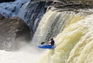
 The accessability and the long whitewater season of the Yough contributed to it becoming the crucible of development in many whitewater disciplines, rafting, inflatable boat design, squirt boating, paddle construction, and whitewater kayaking gear. Here is a sampling of the whitewater legends that got their start on the banks of the humble Youghiogheny River.
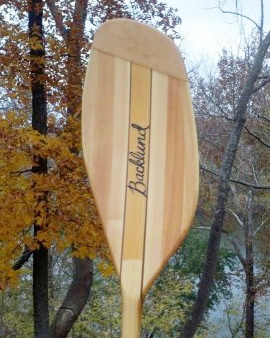
Keith Backlund, a master woodworker who constructed magnificent canoe and kayak paddles, was one of the first “safety boaters” working on the Lower Yough. His apprentices, including Phil Coleman, Jim Snyder, and Jess Whittemore, all paddling legends themselves, credit him with being “a catalyst for excellence” that helped them develop the focus and craftsmanship they needed to produce outstanding work. Backlund’s paddles were said to be some of the finest ever produced, and his knowledge of woodworking was of the highest degree. Backlund passed away in 2012.
Tom Love, the inventor of the Shredder, also started his company by the Yough. In the ‘70s, Love was in the business of raft repair. But in 1978 he decided to focus his energy on crafting his own line of inflatable rafts.
The idea for the shredder came about in the mid-1980s when a friend of Love’s came to him with a request. He needed a boat that was faster than traditional rafts so he could get ahead of commercial trips and shoot video. Since then, other raft manufacturing companies have tried producing similar crafts. But Love’s base in Ohiopyle and his connections in the region ensure that the shredder craze will live on.
Dave Demaree an early guide and slalom racer from the Baltimore area, worked at Wilderness Voyageurs in the early 70’s, then went on to found Demaree Inflatable Boats based in Friendsville, MD. This manufacturer of large inflatables, has gone on to become the preeminent supplier of rafts for Grand Canyon Outfitters and boats for the military.
The founder and co-owner of Immersion Research paddling gear, Kara Weld, also grew up by the Yough. She was raised in Confluence, and learned to kayak with her dad,
Although Ohiopyle had a crew of older guys who paddled every day, Weld was just a kid. And she was a girl. Female paddlers in the ‘80s were far and few between. When a new kayaking school opened in town with a group for kids, Weld signed up. In less than a year, she was racing at her first slalom event. In 1984, Weld earned a spot on the U.S. junior team, which launched her kayaking career.
In 1995, after she married her husband John, they moved back to Confluence and decided to start a kayaking gear company. So Immersion Research (IR) was born in the Weld family basement, where they made rash guards and surf trunks. Now, IR produces everything from base layers to dry suits. It’s a staple brand among Ohiopyle’s many raft guides and paddlers.
The Youghiogheny is also a who’s-who of premier rafting company founders. Many whitewater industry leaders started their rafting careers by learning to guide in Wilderness Voyageurs rafts. John Dragan of Wildwater Unlimited, Imre Szilagyi of Appalachian Wildwaters and John Connelly of Eastern River Expeditons are only three of many.
Since the infancy of commercial rafting in the 1960s, the number of people running the river below Ohiopyle (on guided trips or renting rafts) increased exponentially: from 5,000 in 1968 to more than 100,000 people today.
Wilderness Voyageurs remains the leader on the river, treating more guests to guided and self-guided rafting on the Youghiogheny River than any other rafting company. The second-generation family owners of Wilderness Voyageurs, Eric Martin and his sister Lynne, really mean it when they say they grew up on the Youghiogheny River!
Wilderness Voyageurs
PO Box 97
103 Garrett St
Ohiopyle, Pennsylvania 15470
Call: (800) 272-4141