
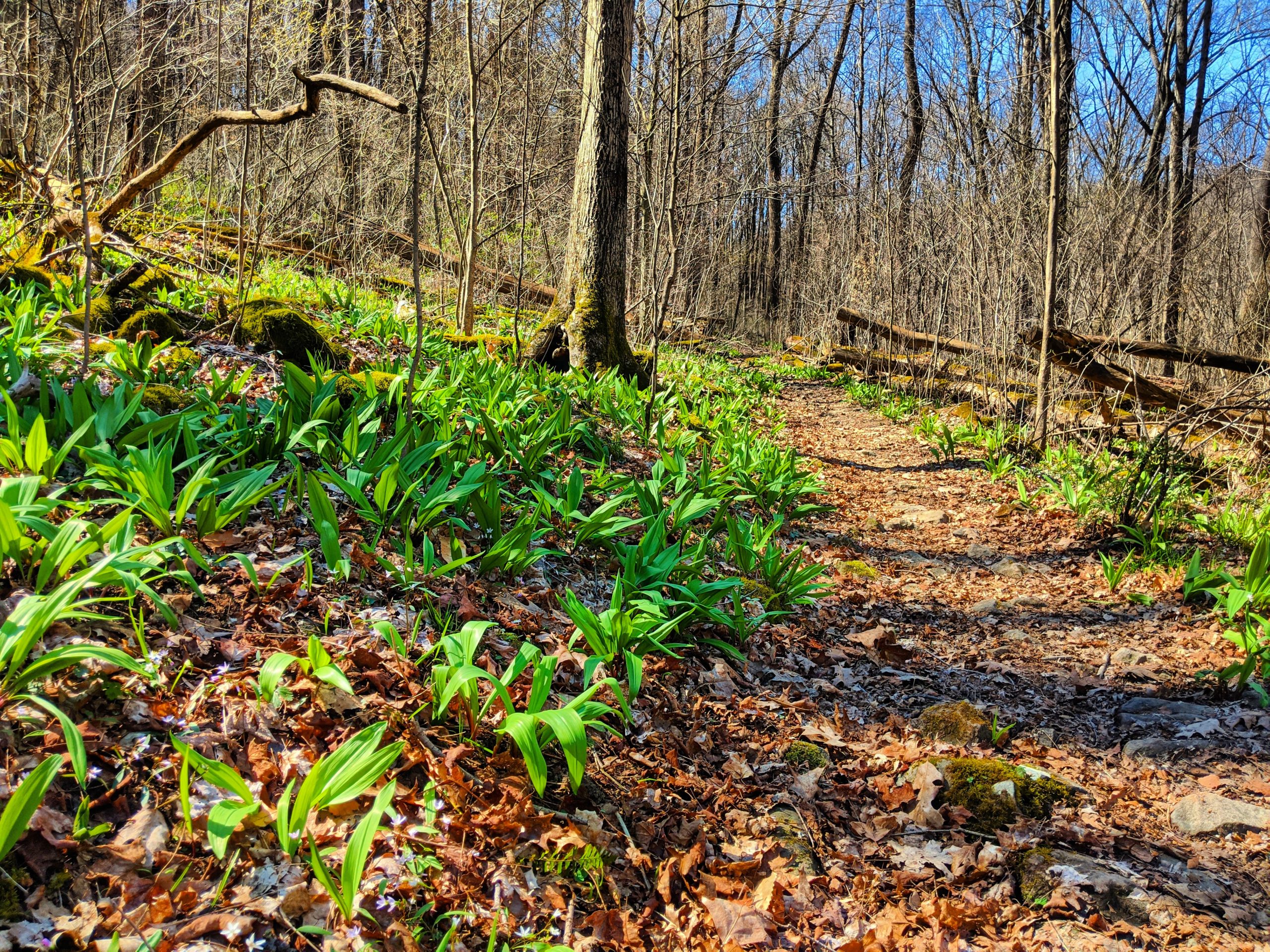
Trail Running in Ohiopyle
I grew up running the trails in Ohiopyle before I knew “trail running” was even a thing. On weekends in the off-season from cross-country and track, our coaches would take the team to the state park for a fun run. We’d jog down some trail, goofing off on the rocks, falling down, swimming in the creeks and overall enjoying a break from running on the road.
Now that I’m an “adult” (and I’ve lived a few more places), I can truly appreciate how good we have it in Ohiopyle.
The trail access and quality is terrific, and you can run in pretty much any weather. From the Ferncliff parking lot, you can get to almost 100 miles of singletrack for running. Most of it is steep, rocky and technical. But there are also a few mostly-flat, entirely pleasant trails that you can run if you’re feeling tired. And if you’re totally beat, you can always hit up the GAP trail for endless miles of totally flat cruising.
Here are a few of my favorite trail runs to do in Ohiopyle.
Some of Ohiopyle’s Best Trail Runs
Meadow Run Loop
 An Ohiopyle classic, this run is a nice, scenic loop without too much uphill or downhill. Any time of year, you’ll get pretty views of Meadow Run, a creek that runs into the Yough River. In the summer, you’re treated to blooming rhododendrons and mountain laurel. Lots of anglers also use this trail for fly-fishing.
Start from the Ferncliff parking lot and head out on Great Gorge Trail, a flat, wide trail above the river. At the end of Great Gorge, follow the path to Cucumber Falls. From Cucumber Falls, the trail starts with rocky terrain at the base of the falls, and then follows along the Yough riverfront for about a quarter mile. There are chances to stop and enjoy watching rafters make their way around Entrance Rapid.
At the mouth of Meadow Run, the trail turns to follow along the stream for a half mile. Here the trail forks, creating the lollipop. Taking the trail to the right will begin the climb to the top of the hill immediately. Taking the trail to the left will follow at the foot of the hill before making the climb. The climb itself is steep and rocky. Run up the creek, past the climbing area, and then take any of the trails at the top of the parking lot. They all lead back down from where you came.
Distance: 5 miles
Difficulty: Intermediate
Climbing: Not too much
Laurel Highlands Up-Down
 The Laurel Highlands Hiking Trail is one of the best features of Ohiopyle State Park, and it starts right at the end of Garrett Street, just steps away from the Wilderness Voygeurs outfitter store! The LHHT is 70 miles long (give or take), running along the ridge of the Laurel Mountains from Ohiopyle, PA to Seward, PA. Overall, the trail is steep and rugged, with lots of rocks, roots and steep pitches. Hikers take a few days to traverse the entire trail, but some runners challenge themselves by tackling the whole trail in a day during the Laurel Highlands Ultra.
One of my favorite parts of the trail to run is from mile marker 0 (the end of Garrett St. in Ohiopyle) to mile marker 3 at the top of the first climb. The mile markers aren’t quite correct, so the whole out-and-back run is actually only about 5.5 miles.
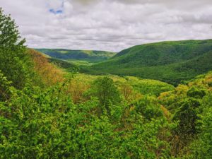
After some gently rolling trail and a whole lot of rocks in the first mile, the climb really starts. For about a mile, you’ll gain nearly 700 feet in elevation, topping out at a fantastic overlook of the Yough River. Keep climbing from the overlook and enjoy the flattish, easy terrain for about another half-mile until you reach mile marker 3. I usually turn around to enjoy the downhill from this point, because the trail soon makes another steep descent and ascent between miles 3 and 4.
Distance: 5.5 miles
Difficulty: Advanced
Climbing: A lot
Kentuck – Sugar Run – Mitchell Fields
 You shouldn’t see too many other people on this loop, especially if you go during the week. It’s a bit more rugged than some of the busier routes, but definitely worth the effort.
 You shouldn’t see too many other people on this loop, especially if you go during the week. It’s a bit more rugged than some of the busier routes, but definitely worth the effort.
From the Ferncliff parking lot, run over the high bridge and up the gravel road to the campground (“run” might be an exaggeration on this super-steep hill). Go through the campground, past the upper parking lot and down the chunky gravel descent labeled “Kentuck Trail.” Meet up with Jonathan Trail for a minute, then turn off onto Sugar Run. This trail climbs gently up to Old Mitchell Place, a parking lot and field that used to be a farmstead.
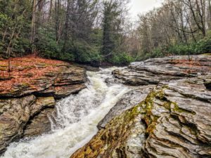
Hunt around for Mitchell Trail, which is a grassy path to the right of the parking lot. Run down the trail, bearing right at the intersections so you don’t get stuck running the snowmobile loop (not fun). Descend all the way to Sugar Run Falls, a beautiful cascading waterfall with a nice calm pool. The waterfall runs year-round, but it’s prettiest in the spring and after a big summer rain. It’s a great place to take a dip if it’s hot.
You’ll pop out on the GAP trail, and it’s about 2.5 miles back to the parking lot where you started.
Distance: about 9 miles
Difficulty: Intermediate
Climbing: A lot
Kentuck Loop
 This run is the least technical of the bunch, but has a couple good climbs to make up for it. Starting from the Ferncliff parking lot, run up the gravel road to the campground. Go left by the registration booth, and you’ll find yourself on Kentuck Trail. Follow this rolling, well-maintained trail all the way to the Tharp Knob overlook, where you’ll get an excellent view of downtown Ohiopyle. Cruise back down the way you came, or turn off onto Great Gorge trail for a steep, rocky descent.
Distance: 7 miles
Difficulty: Intermediate
Climbing: Some
Canyon’s Edge and McCune Loop
 This is a great loop to run on a really hot day, because it’s high up on cool, breezy Sugarloaf hill. It’s also a super-scenic place to be in the fall when the leaves start changing.
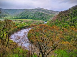
Start from the Sugarloaf sledding hill parking lot and run out Canyon’s Edge trail, taking the first two right turns. You’ll meander along Upper Canyon’s Edge for a while, enjoying the gentle switchbacks and soft terrain. This leads to the bottom of McCune Trail. Follow McCune to the right, through the parking lot, and take the first left turn. It’s a short, steep climb to the top of McCune. Hang a left on McCune and run through the ferns and big, mossy boulders. The trail winds its way back down the hill, with a stopping point at an overlook of the valley below. Take the first right, and you’re back on Upper Canyons Edge, which you can follow back to the parking lot.
If you want to add on about four more miles, continue downhill from the parking lot onto Sugarloaf trail (it picks up at the edge of the field). Run down until the Baughman trail intersection across the road, continue down Upper Baughman to the overlook. It’s one of the best views in the park, any time of year. Keep running a short way down Baughman to the flagged trail across the road. Take the connector trail back to Sugarloaf, go back up the hill, and you’ll end up back at the sledding hill parking lot.
Distance: 7-10 miles
Difficulty: Intermediate
Climbing: Some
If you have any other questions about the trails around Ohiopyle, give us a call at 800-272-4141!