Cheat River History – Then and Now
The magnificent Cheat River flows from five major tributaries, known as the “Forks of the Cheat”, which originate in the rugged Monongahela National Forest and join to form the main river stem near Parsons, West Virginia.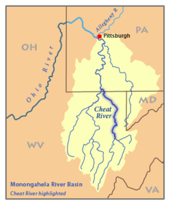
- Black Fork
- Dry Fork
- Glady Fork
- Laurel Fork
- Shavers Fork
The Shavers Fork is acknowledged as the starting point of the Cheat River and emanates from the crest of Cheat Mountain at 4,848 ft, making it the highest river in the Eastern US. From Parsons, the scenic Cheat flows nearly 78 miles past the historic river towns of St. George, Rowlesburg and Albright before reaching Cheat Lake and discharging into the Monongahela River at Point Marion in Pennsylvania at an elevation of 810′. The Cheat River flows north throughout its entire length. The complete watershed spans an impressive 1422 square miles, and the river is one of the longest un-dammed waterways in the eastern United States.
Early Settlers and Industry of the Cheat River
This area was home to the Lenape People of the Delaware Nation, theeir name for the Cheat was Ach-sin-ha-nac, meaning “stony river”. It does not appear that there were significant permanent native american villages in the Cheat River drainage, this is probably due to the steepness of the terrain and the harshness of winters.
European settlers and trappers roamed the basin starting in 1736. The famous cornerstone, The Fairfax Stone, was placed in 1746 indicating the divide between the headwaters of the Potomac River and the Cheat River. The Dunkards, a religious sect, were the first Europeans to settle on the Cheat River, in 1756, they established a village where present day Camp Dawson is located near Kingwood, WV. The Dunkards were forced to abandon this settlement due to the ongoing hostilities related to the French & Indian War. In the upper reaches of the Cheat drainage the earliest claim was in 1766 when John Crouch established “tomahawk rights near Parsons, although the town was not incorporated until 1893.
And what history in this part of the country would be complete without mention of good ol’ George Washington. George Washington visited in 1784 and wrote: ‘‘Cheat at the Mouth is about 125 yards wide—the Monongahela near dble that—the colour of the two waters is very differt [sic ], that of Cheat is dark, the other is clear.’’ The darkness of the water of the Cheat River can be attributed to one of the primary tributaries, due to the high tannins content of the water from the Hemlocks and Spruce that dominate the headwaters.
The Cheat Valley was rich in natural resources of timber, coal and water and “easy transportation”. This combination of resources led to the creation of some of the earliest iron industry in the US contributing greatly to the armaments of the war of 1812, cannonballs made along the Cheat River were used in the Battle of New Orleans. The iron industry continued to boom in the mid 1800’s peaking around 1850. The Virginia Iron Furnace built in 1854 is still visible as you approach Albright, WV from the north along Muddy Creek. The iron industry along the lower reach of the river supported roughly 3,000 settlers, with the epicenter being at Cheat Neck, the site of current day Cheat Lake, a few miles above the confluence with the Monongahela.
Flora and Fauna of the Cheat River
The Cheat River watershed is considered a biodiversity hotspot, a portion of it became a West Virginia Natural Area in 2014. The center of what boaters know as “The Cheat Canyon” is considered one of the most “ecologically intact” areas in the Central Appalachians by The Nature Conservancy, due to the absence of dams and the river’s connection to well-forested headwaters. In fact, land use within the watershed is dominated by forest, at a stunning 84.9% of the drainage.
Floating down the river you stand a good chance of seeing the region’s display of rare endemic flora, fauna, and wildlife, from towering Hemlocks, to black bear and bobcat, bald eagles, and the rare large-flowered Barbara’s buttons in the rock scrabble on the shore. More than ten endangered, threatened, or globally rare species occur in the Canyon, including the flat-spired three-toothed land snail, which exists nowhere else on earth. The other rare fauna that are hiding out in the hollers include Cheat Mountain salamander, Indiana bat, and the West Virginian northern flying squirrel.
The Cheat River above Pringle Run ( Narrows takeout) is an active fishery, boasting a lively small mouth bass population in addition to catfish and rainbow trout. Several Cheat River tributaries maintain native brook trout populations
Water + Gradient = whitewater
The size of the watershed and lack of dams has made the Cheat River famous in whitewater circles because of the highly variable flows. One day the flow may be less than 1000 cfs, and the next day it will bee 10,000 cfs. To place in context, rafting river levels are between 1.5 feet ( 800 cfs) and 8 feet (8000 cfs).
Here are the top 3 Cheat River Historic Crests
(1) 36.90 ft on 11/05/1985 estimated to have been 170,00 cfs
(2) 24.20 ft on 01/19/1996
(3) 23.58 ft on 02/09/1994
The flood of 1985, known as the Election Day flood, decimated the lower Cheat Valley. Nearly half of the towns of Rowlesburg, WV and Albright, WV were leveled and homes were found many miles downstream in the Cheat Canyon.
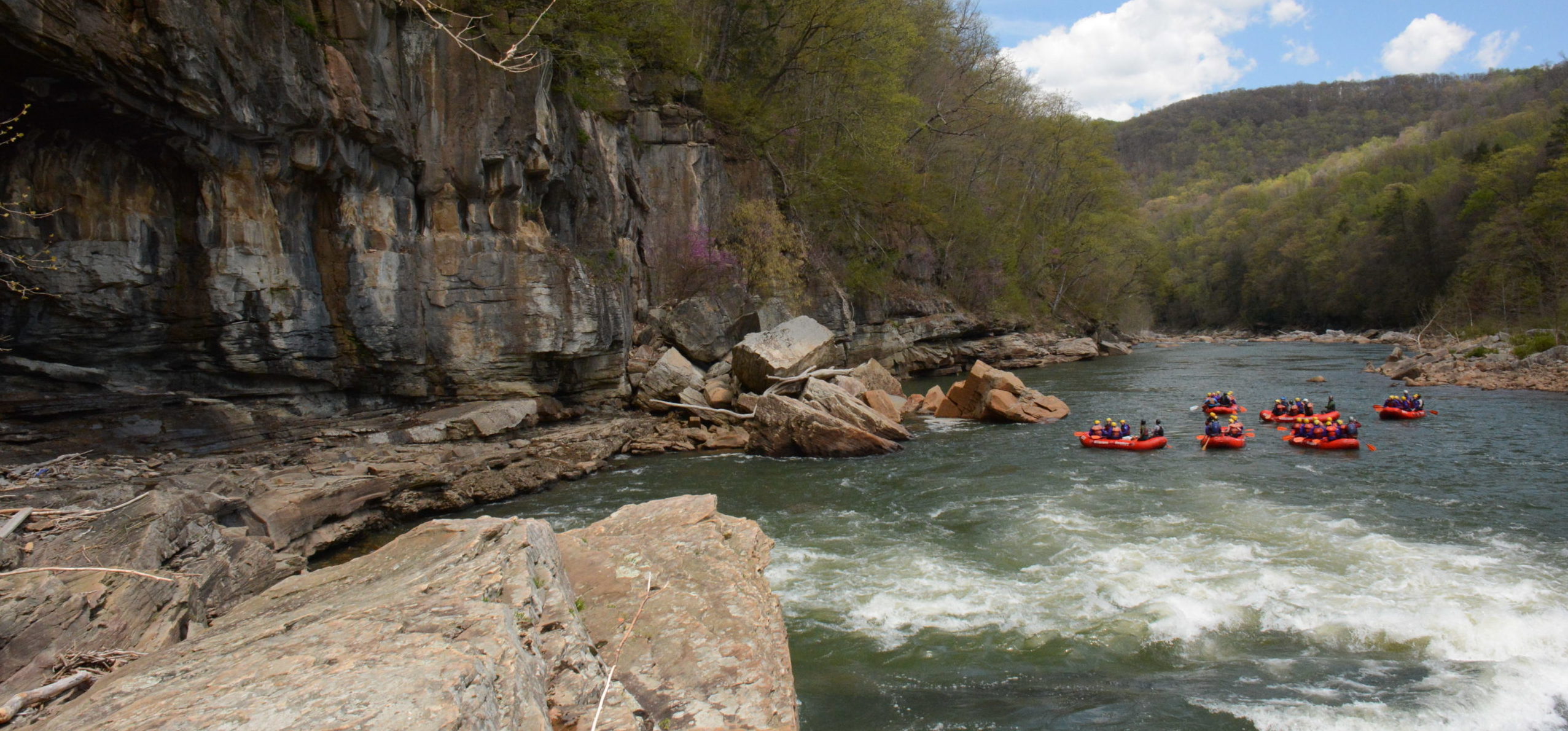
The first known descent of the Cheat River by a whitewater enthusiast happened in 1954 when John Berry, led a group that took 2 days to descend what we now call the Cheat Canyon. The Cheat Canyon is an 11 mile section of river from Albright, WV to Jenkinsburg, WV that contains giant boulders that create 27 significant rapids, a class III-V puzzle of whitewater rapids. The whitewater rafting industry on the East Coast started on the Youghiogheny River, one drainage to the north in 1964, shortly thereafter in 1968, the Cheat River rafting industry began. The Cheat became renowned for it’s rowdy ways, the big water and dramatic fluctuations attracted rafters from all over the US. The Cheat rafting industry went from nothing to 40,000 rafters in just 10 years, all of this activity took place during the 8 weeks of April and May. This breathed some serious life back into the Appalachian back water of Albright, WV (pop. 357 in 1980)
The Cheat River is best known for rowdy spring rafting on the Cheat Canyon when flows are highly variable due to spring rains. The 11 mile run is done in a number of types of raft, the “standard” format for a Cheat rafting trip is an 8 person raft, with 7 clients and a guide at the helm. The variable flows mean that a smaller raft may be used to accomodate lower flows, yet still provide a big water feel and an amzing day in a wildreness canyon.
Check out Cheat Canyon rafting trips.
The amazing whitewater playground that is created by more than 150 miles of whitewater in the Cheat River drainage became a magnet for diehard paddlers and innovaters in the whitewater sport. Along the banks of the Cheat the following companies have impacted the sport world wide:
- Riverstyx – Jimmy Snyder founder of Squirtboating and prolific boat designer and paddle builder
- Custom Inflatables – Inventor of the Thrillseeker and one of the few US raft manufacturers
- Appalachian Wildwaters/ USA Raft – Was the largest rafting outfitter in the US during the 80’s and 90’s HQ was Rowlesburg, WV
Cheat River Whitewater Sections
Throughout the headwaters of the Cheat River there are hollows filled with “cricks” and when the snow melts or the rain falls, these become a whitewater playground unmatched in the US. More than 150 miles of steep and small creeks that are boatable by experienced kayakers exist above the main stem of the Cheat. Do not be alarmed if you are driving around this beautiful country and what casually resembles a pool toy goes launching off a 15 foot water fall. Below are the primary and accessible to the public sections of whitewater that make up the main stem of the Cheat:
Upper Cheat Class I-II Parsons, WV to St. George WV, 14 miles Blackwater Outdoor Adventures offers rentals
Seven Islands Class I-II Hannahsville Ford to Riverview Lounge, 12 miles Blackwater Outdoor Adventures offers rentals
Cheat Narrows Class II-III Rowlesburg, WV to Pringle Run, 5 miles
Cheat Canyon Class III-IV+ Albright, WV to Jenkinsburg, WV 11 miles
Towns of the Cheat River
The watershed is still very sparsely populated due to the rugged character of the mountains that the river carves through. The cutting of the river has established very steep walls pretty much down to the rivers edge. There are few small flat “bottoms” that have been town sites over the years, most of these towns have shrunk as the extractive industries have reduced their economic footprint and the railroad disappeared. The flood of 1985 also contributed greatly to the decline of these towns when 3500 homes were destroyed in the river corridor.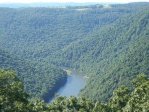
- Parsons, WV population 1485 located at the confluence of the Forks of the Cheat
- Rowlesburg, WV population 584 a former railroad town and site of a Civil War skirmish
- Albright, WV population 259 epicenter of the whitewater community in the valley
- Point Marion, PA population 1159 located at the confluence with the Monongahela
Coal Mining Legacy of Appalachia
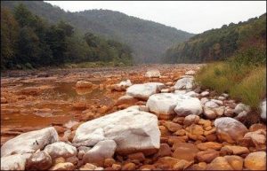
In the late 1980s, whitewater paddlers on the Cheat River noticed the water quality degrading. Acid mine drainage (AMD) was discharging from abandoned mine lands and active coal mines into the river. AMD occurs when water, oxygen, and bacteria come into contact with pyrite, a mineral that is often associated with the Upper Freeport coal seam. Every year, more rocks in the river were stained bright orange. People started complaining of stinging eyes and dryskin after spending time in the Cheat’s waters. (Right now over 7500 miles of streams in Appalachia are polluted by AMD from abandoned mine lands.)
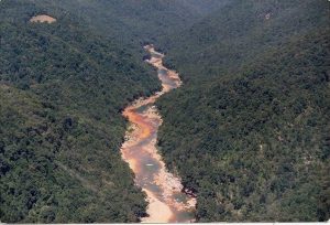
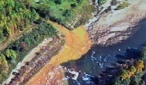
In the spring of 1994, polluted water from an illegally-sealed major underground coal mine blew out the hillside and poured into Muddy Creek. The huge release of mine water entered the main stem of the Cheat River just upstream of the Cheat Canyon. The the river ran orange for miles. The resulting discharge impacted not only the Cheat Canyon, but also lowered the pH in Cheat Lake to 4.5, killing fish as far away as 16 miles downstream. A second blowout in 1995 further made the problem worse. American Rivers, Inc., a national river conservation organization, named the Cheat as one of the nation’s ten most endangered rivers. After the mine blowouts, the Cheat’s whitewater industry suffered over a 50% drop in business, while whitewater participation increased nationally by 33% during the same time period.
The mine blowouts forced the issue into the public eye. Concerned citizens and stakeholders organized Friends of the Cheat (FOC) to begin to address the problems resulting from over a century of coal mining. FOC’s goals were to restore, preserve and promote the natural qualities of the Cheat River watershed, and to mobilize an effort by government, private industry, landowners and grassroots organizations to deal with the serious problems due to acid mine drainage in the watershed.
This effort led to the formation of the River of Promise (ROP) task force in May 1995. Over 20 groups have signed onto the “River of Promise: A Shared Commitment for the Restoration of the Cheat River, West Virginia.” The first signatories were Friends of the Cheat, West Virginia Rivers Coalition, Anker Energy, West Virginia Division of Environmental Protection, West Virginia Division of Natural Resources, and the Department of Interior Office of Surface Mining. By 1996, signatories included more state and federal agencies, academia, conservation groups, and local governments. Meeting quarterly and chaired by Friends of the Cheat, the ROP task force coordinates and initiates projects throughout the watershed. Millions of dollars in projects have been implemented since 1995, including water monitoring programs, water quality assessments, and reclamation projects.
Then – 1980’s
Now- 2018
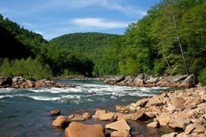
Now the Cheat is off the list of endangered rivers, whitewater rafting trips are running, and fish are making a comeback. In early April of 2017, Wilderness Voyageurs’ guides observed stoneflies on the Cheat. Stoneflies are a species of insect that indicates a healthy marine ecosystem.
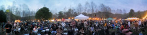
FOC has hosted the Cheat River Festival by the river banks in Albright, West Virginia every May since 1995. Bands from all over Appalachia play live music, while Fest goers dance, browse the Art Market, learn about other non-profit organizations that share the FOC vision, place bids at the silent auction, eat great festival food, and support the FOC’s quest to make a clean, healthy watershed. For athletes, there’s a 5K foot race and a Down River Race through the Cheat Canyon. The festival takes place the first weekend of May, come show your love for the Cheat!
Can’t make it to the festival? You can donate to Friends of the Cheat.
Come on out in the spring to experience this amazing corner of the world and to witness the resilience of nature up close and personal. Remember Cheat Canyion rafting trips are available April 1 through Memorial Day. Throughout the summer, following rain events, we sometimes are fortunate enough to be able to operate improptu raft trips to take advantage of river levels, join our Adventurers Club to be in the know.
Wilderness Voyageurs
1-800-272-4141
PO Box 97
Ohiopyle PA 15470